
A low-density subdivision may look simple on a site plan: detached homes, wide streets, driveways, parking, and landscaped setbacks. The architectural effects become clearer in daily use, when routine trips require more land, longer utility networks, and usually a car. Buildings are no longer part of a connected public setting; they must compensate for distance, limited walkability, and dispersed services.
Urban sprawl is the outward expansion of development onto previously rural or undeveloped land at relatively low density. Detached housing alone does not define it. A compact village may consist largely of detached homes, while a sprawling district can include apartments, retail boxes, offices, and warehouses separated by oversized roads and parking areas. For architects, developers, and public clients, the distinction affects the project brief, infrastructure costs, approvals, operating performance, and future adaptability.
Buildings become isolated systems
In compact districts, streets, transit stops, schools, shops, parks, and housing support one another. In dispersed development, individual plots often operate as self-contained islands. A house needs a private driveway and often a garage; a school needs substantial drop-off space; a clinic may require extensive surface parking; and retail relies on visible roadside access.
These conditions shift architectural priorities. Entrances are often organized around vehicle arrival rather than walking. Facades along arterial roads may function mainly as signage or buffers, while pedestrian-facing edges receive less attention. Service yards, loading areas, parking lots, and stormwater facilities can take up a large share of the site before the building footprint is even settled.
The issue is not only visual. Public-facing buildings become less useful as everyday destinations when the surrounding street network is discontinuous and major roads are difficult or unsafe to cross. This affects libraries, community centers, medical practices, and local shops alike.
Land consumption drives site and infrastructure decisions
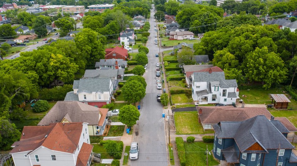
Sprawl spreads infrastructure across more land per resident or employee. Roads, water mains, sewers, power lines, fiber networks, streetlights, drainage systems, and emergency-service routes must serve fewer users per linear meter. Initial costs may be divided among the developer, utility provider, and municipality, but they do not disappear. Maintenance liabilities can remain for decades.
What this means during early design
A feasibility study should test infrastructure capacity before the building program or site layout is fixed. A parcel on the metropolitan edge may appear inexpensive but still require off-site road improvements, a pumping station, extended water mains, additional wastewater-treatment capacity, or new fire-service access. Where public sewer service is unavailable, on-site wastewater systems introduce constraints related to soils, setbacks, reserve fields, and future expansion.
- Confirm available utility capacity and connection points, not just the presence of nearby lines.
- Model peak vehicle trips, service access, school drop-off, and emergency-vehicle circulation.
- Protect routes for future utility expansion and avoid placing permanent structures over them.
- Size stormwater systems for final build-out, including cumulative impervious surfaces.
- Calculate lifecycle maintenance responsibilities for private roads, drainage ponds, lighting, and shared infrastructure.
Surface parking is especially influential. Large paved areas increase runoff, retain heat, lengthen walking distances, and fragment the site. Parking demand should reflect actual occupancy patterns, local code requirements, shared-use opportunities, transit access, and accessible-parking rules rather than a generic template.
Mobility reshapes the building brief
Car-dependent growth changes room schedules as much as traffic studies. Homes need more storage for vehicles and outdoor equipment. Commercial buildings require larger customer parking areas and delivery circulation. Schools and healthcare facilities need carefully separated zones for buses, staff, visitors, patient drop-off, ambulances, and service vehicles.
These functions need to be designed for safe use, not simply fitted onto the site. Pedestrian-vehicle conflicts are common on suburban sites when walking routes are treated as leftover strips between curbs. A well-planned site provides continuous, shaded, accessible routes between transit stops, parking areas, and entrances, with raised crossings where suitable, clear sightlines, lighting, and weather protection at waiting areas.
Development teams should also account for changing travel patterns. Electric-vehicle charging requires electrical capacity, a load-management approach, conduit routes, and appropriately located bays. Bicycle storage and micromobility parking must be close enough to entrances to be practical. A building with no realistic alternative to driving is more exposed to fuel-price changes, congestion, and changing parking policy.
Environmental performance is tied to the wider pattern
A highly efficient building can still occupy a land-intensive development pattern that increases transport energy use and disturbs large habitat areas. Architecture cannot determine every regional planning decision, but site placement, grading, planting systems, and durable construction can reduce impacts at the project scale.
The first site decision is often the most consequential: preserve existing trees, drainage corridors, wetlands, and steep slopes by placing buildings and roads on already disturbed or less sensitive land. Compact building footprints can retain more continuous open space than scattered structures, even where total floor area is unchanged.
Stormwater design requires more than underground pipes. Permeable paving, bioswales, rain gardens, planted detention areas, and shorter curb runs can slow and filter runoff. Their performance depends on soils, slopes, groundwater conditions, maintenance access, and realistic management plans. Decorative planting without a maintenance plan should not be treated as functional green infrastructure.
Public services need flexible, reachable buildings
A dispersed population makes public facilities harder to locate efficiently. A school, health center, fire station, or recreation facility may serve a wide catchment area, increasing travel times and creating pressure for more parking and vehicle circulation space. At the same time, these buildings are often expected to support community activity outside their core hours.
Design can retain that civic function through safe pedestrian connections, reserved space for future transit stops, and a clear separation between publicly accessible spaces and secured operational areas. A school gymnasium or clinic education room, for example, can have a separately controlled entrance and toilets for after-hours use. Healthcare projects require particular attention to arrival sequences, accessibility, infection-control separation, and emergency access; our guide to healthcare facility design for workflow, comfort, and operational performance examines these building-level requirements in more detail.
Approval and cost risks are concentrated at the edge
Peripheral sites may involve layered approvals for land-use designation, subdivision rules, road-authority permits, environmental review, drainage approvals, utility agreements, and fire-access requirements. The costliest revisions often occur when these constraints are considered only after concept design is underway.
| Decision area | Common sprawl-related risk | Early design response |
|---|---|---|
| Access | New turning lanes or restricted driveway permits | Coordinate traffic access with the road authority before land plan approval |
| Utilities | Insufficient water pressure or sewer capacity | Obtain utility assessments and allow for off-site works |
| Drainage | Downstream flooding or oversized detention requirements | Assess the full watershed and preserve natural flow paths |
| Fire safety | Long response routes and limited turning space | Test apparatus access, hydrant coverage, and emergency egress early |
| Phasing | Early infrastructure oversized for initial occupancy | Plan service corridors and phased systems without blocking later connections |
Architectural strategies that reduce long-term rigidity
Where outward growth is planned or unavoidable, a single project cannot resolve regional policy on its own. The practical aim is to avoid fixing the site into one car-dependent pattern for its entire life. Mixed-use nodes, adaptable ground floors, connected street grids, small blocks, shared parking, and a clear hierarchy of public and private open space leave more options for later phases.
Higher density near services does not have to sacrifice privacy or daylight. Building orientation, courtyard layouts, street-facing entrances, screened outdoor areas, and careful window placement are more effective than simply increasing setbacks. Practical approaches to this balance are covered in designing dense housing that works for residents.
For a phased suburban project, an infrastructure and public-realm plan can serve as a useful control document. It should identify the final street network, pedestrian links, utility corridors, tree zones, drainage land, transit-stop locations, and future building parcels. Each early phase should provide its share of these permanent elements rather than deferring them until the final parcel is sold.